Crossing the Gulf Stream from Florida to the Bahamas by boat takes more planning than most passages. The current will push you north the entire time you’re in it, your heading and your actual course will never match, and if you don’t account for all of that before you leave the dock, you’ll end up somewhere you didn’t intend to be.
I remember how confused I was the first time I tried to work this out before our 2016 crossing. A friend who had made the trip many times sat down with me and walked me through it in plain language. That’s what I’m going to do here.
Understanding the Gulf Stream
The Gulf Stream is a river of warm water inside the Atlantic Ocean. Between Florida and the Bahamas, it runs north. Between Florida and Cuba, it runs east. It typically averages 2 to 2.5 knots.
If you leave Florida and head due east (90 degrees), every hour you travel you will move east at your boat speed AND north 2 to 2.5 miles. That northerly push is an average. You’ll move more in the center of the stream and less at the edges. But the average is what matters for route planning.
A few things make the Gulf Stream more demanding than a typical passage:
- The warm water generates more thunderstorms than the surrounding ocean
- It carries heavy commercial ship traffic heading up and down the East Coast
- Smaller boats are constantly crossing between Florida and the Bahamas
Crossing as quickly as possible reduces your exposure to all three of these.
Here’s a live current map showing the Gulf Stream right now:
You can learn how to read it in detail in Gulf Stream Location, Speed and Counter-Currents.
Before you leave, also make sure you have a solid weather window lined up. Any northerly wind component turns the Gulf Stream into dangerous, steep chop. Picking Weather Windows covers exactly what to look for.
Two Terms You Need to Know
Heading is where the bow of your boat is pointing. It’s what shows on your ship’s compass and what you set on the autopilot.
Course over ground (COG) is the direction the boat is actually moving across the water. It’s what your chart plotter shows.
In the Gulf Stream, these two will never be the same. Your COG will always be north of your heading because the current is pushing you north the whole time.
Understanding this difference is the foundation of all Gulf Stream route planning.
How to Plan Your Route
The goal is to leave from a point far enough south of your destination that the current sweeps you right to it. Here is the math, using a real example.
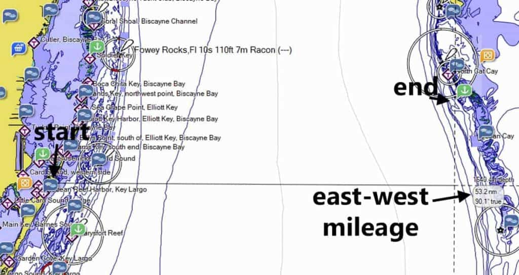
Step 1: Measure the east-west distance.
Measure only the east-west component between your departure point and your destination. Not the diagonal distance between the two points. Just the east-west distance.
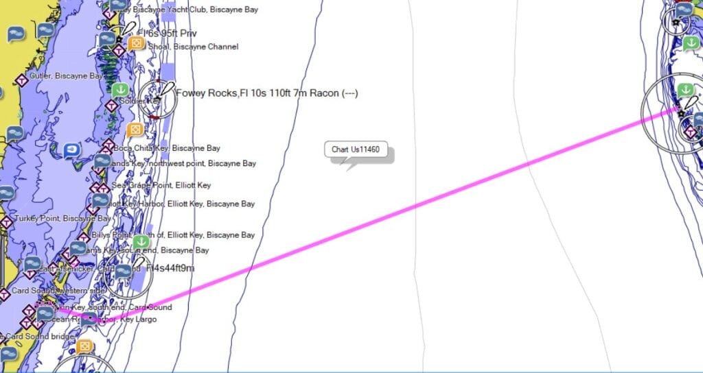
In our example, we were thinking of leaving from Angelfish Creek and heading for Gun Cay. The east-west distance was 53.2 miles. (Note: Angelfish Creek is only suitable for shallow-draft boats. We draw 3 feet.)
To figure this with a real-life example of leaving from Angelfish Creek:
Step 2: Calculate how long the crossing will take.
Divide the east-west distance by your average boat speed without current.
Our average speed is about 6 knots, so: 53.2 miles / 6 knots = about 9 hours.
Step 3: Calculate how far north you will be pushed.
Multiply the hours by the Gulf Stream’s average speed. I use 2.5 knots as my planning figure, which tends to work well as a conservative estimate. Check the current map to get a feel for real conditions on your planned departure day.
9 hours x 2.5 knots = 22.5 miles north.
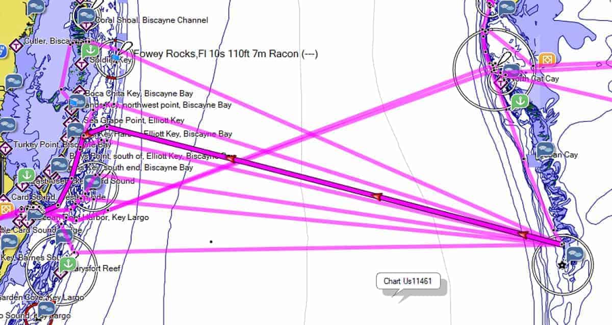
Step 4: Find a departure point that far south of your destination.
In our example, we needed to leave from a point about 22 miles south of Gun Cay. But Angelfish Creek is only about 15 miles south of Gun Cay. Even at 2 knots in the stream, that’s 18 miles of northing. It might not work.
So I looked at alternate destinations on the Bahamas side instead. There are several anchorages up to 28 miles north of Gun Cay. I marked the most appealing ones and planned for multiple possible stops depending on how far north we actually got pushed.
I always plan alternate destinations before any Gulf Stream crossing. If weather turns rough, if the trip takes longer than expected, or if sunset is closing in, having options already plotted and evaluated makes all the difference.
The result on that trip: we made better-than-expected time and came in right at Gun Cay, with a bit of counter-current on the Bahamas side helping us along.
Your Heading Must Never Point South
For a fast crossing, one rule applies on every eastbound crossing: your heading should never go south of due east (90 degrees).
Any amount south of due east and you’re fighting the current. We discovered this the hard way: turning just two degrees south of due east dropped our speed over ground by more than half a knot. A few more degrees south and it dropped nearly a full knot. Do not fight the Gulf Stream.
The same principle applies on the return trip: your heading should never go south of due west.
Tips for the Crossing
Start with a clean bottom. A clean hull is one of the best things you can do before you leave. Faster speed means less time in the stream, which means less northing and less exposure to traffic and weather.
Motor or motor-sail at your best cruising speed. Pure sailing across the Gulf Stream is a dream. It’s rare to get conditions that allow a fast crossing under sail alone. If you do have engine trouble and have to slow down, plan for more northing than your math predicted and have alternate destinations ready.
Ships are faster than they look. You will almost certainly have to cross, duck, or wait for commercial traffic somewhere in the stream. Speeds are deceptive out there. Be very cautious about trying to cross in front of another vessel.
If you have to pause, head south. If ships are coming from both directions at once, slow down and turn south briefly. Simply cutting speed lets the stream keep sweeping you north. Ships in the Gulf Stream typically run 20 to 25 knots and will be past you quickly.
Have your documents in order before you go. See the Bahamas Checklist for the full list of what you need for entry, including the customs decal, MMSI requirements, and quarantine flag.
Crossing from Miami or Fort Lauderdale to Bimini
Bimini is actually south of Miami. That creates a specific problem: to reach it, you either fight the current all the way across, or you allow the stream to push you north and then make your southing on the Bahamas side.
Neither option is easy. Both add hours to the trip.
The better third option is to use your weather-waiting time to move south to a different anchorage before you cross. Which one depends on your draft.
If heading south first is not practical, my preference is to cross due east and make any necessary southing on the Bahamas side. The Gulf Stream usually does not run right to the islands, and there is often a counter-current on the east side. Cross the stream, then turn for your destination.
If you decide to fight the current, you can set waypoints as usual and steer to follow the rhumb line. Be aware that your speed over ground will likely be at least a knot below your typical average. Plan the timing accordingly.
Crossing from the Keys
If you are starting further south, say from Rodriguez Key at Key Largo, the planning is the same. Figure the east-west mileage, divide by your average speed to calculate how far north you’ll be pushed, and mark that point due south of your destination on the chart. Your steering heading should be slightly less than 90 degrees to keep you near the rhumb line as the stream pushes you north throughout the trip.
Because a Keys-to-Bahamas crossing is longer, the math is a less perfect estimate. Expect to tweak your heading in real time as you see how conditions develop.
Westbound Route Planning (Return Trip)
The return from Bimini to Florida is planned the same way, just in reverse. You want to leave from a point south of your Florida destination so the stream pushes you toward it rather than past it.
On our return, we could not start as far south as the math called for. The Bimini chain does not extend that far south. Our options were to fight the current or get across quickly and handle the southing inside Hawk Channel on the Florida side.
We chose to cross fast. Here is how we added a useful twist: we used a day with northeast winds (not good for crossing) to work south along the Bimini chain to Riding Rock. A counter-current helped. That got us about 15 miles further south than leaving from Gun Cay, putting us only about 4 miles south of Angelfish Creek on the Florida side.
Creating Multiple Westbound Routes
I created a series of potential westbound routes for the various places we might cross the Florida reef and enter Hawk Channel, including routes I thought were unrealistically far south and north. I planned them all before we left.
We steered due west as we crossed. The chart plotter only shows one route at a time, so I started with the southernmost one. As the stream pushed us north of that rhumb line, I pulled up the next route north, and so on. We crossed the reef, entered Hawk Channel, and sailed south to Angelfish Creek.
We would have covered fewer miles fighting the stream. But I don’t think it would have saved us much time, and we got out of the stream, its traffic, and its weather far more quickly.
Ready to Make the Crossing?
The Gulf Stream is just the beginning. Once you’re through it, there’s a lot more to work out: where to clear customs, how to handle Bahamas paperwork, provisioning, communications, weather while you’re there, and how to move around the islands. My course Get Ready to Cruise the Bahamas walks you through all of it step by step, so you can prepare before you leave and just enjoy the trip once you’re there.
For on-the-water reference, the Bahamas Cruising Guide puts anchorages, entry ports, tides, and services in a table format built for fast lookup.
Get Ready to Cruise the Bahamas:
Bahamas Cruising Guide:


Carolyn Shearlock has lived aboard full-time for 17 years, splitting her time between a Tayana 37 monohull and a Gemini 105 catamaran. She’s cruised over 14,000 miles, from Pacific Mexico and Central America to Florida and the Bahamas, gaining firsthand experience with the joys and challenges of life on the water.
Through The Boat Galley, Carolyn has helped thousands of people explore, prepare for, and enjoy life afloat. She shares her expertise as an instructor at Cruisers University, in leading boating publications, and through her bestselling book, The Boat Galley Cookbook. She is passionate about helping others embark on their liveaboard journey—making life on the water simpler, safer, and more enjoyable.
Pat Harris says
Carolyn — thanks thanks thank! I loved this article, very helpful for first-timers!
Keith & Nicki, s/v Sionna says
Such a simple, straightforward and USEFUL description of the planning process! Thanks Carolyn!
Peter Tarantola says
Great article
The Boat Galley says
Thanks so much!
Jason Diesel says
I was hoping you would add a little about a northerly wind component, washing machine, or easterly, etc. and waiting for a window that is more favorable than another. All this is really only gleaned from experience.
The Boat Galley says
Weather is a different component. I really wanted to keep this discussion to simply routing and how you have to plan for the offset to the north. Weather is another big component, but everyone’s tolerance for conditions is different!
John Casey says
Another great article Carolyn.
Dave Skolnick (S/V Auspicious) says
It is worth noting that “conventional wisdom” is often unwise. Fighting the Gulf Stream is, to put it bluntly, a sucker bet. That means Lake Worth to West End is a bad idea. If your crossing the Gulf Stream in a six knot boat you should pick a destination 25 nm North of where you start, in both directions.
S/V. ZIG~ZAG says
I think we have crossed the stream about 10 times, and it is always different. However- the formula remains the same. Don’t fight mother nature. Excellent article.
Carolyn Shearlock says
Thanks!
Fred says
Having done the crossing dozens of times in our Dufour 34, I can tell you the best and easiest way to get to Bimini is to leave from Cape Florida…. There used to be a well known light there, called BUG LIGHT. We always left at around 8pm or so…. not long after dark… sail all night and plan on arriving in Bimini as the sun rose in the east. You dont want to try to enter the harbor in Bimini in the dark! If we arrived early, we would wait till the sun started to show in the east before attempting the entry. Then again, we drew 6’6″… and would frequently bump on the way in.
Fred says
We, of course would compensate for the Gulf Stream…stearing somewhere around 120 degrees magnetic if memory serves me…it’s been a long time since the last trip ….you can’t get lost if the weather is decent…you can see the glow of the lights in Bimini most of the way! Our club frequently held overnight races to Bimini or to West End.
Carolyn Shearlock says
Leaving from that far north, you will be fighting the Gulf Stream the whole way, as I discussed. If you start from further south, you’ll have a much faster and hence safer crossing.
Fred says
We actually would always leave from Cape Florida….at the southern tip of Key Biscayne. It’s perfect as you progress across the stream, you wash northwards toward Bimini. On sone trips when the stream isn’t running as hard, we have actually had to tack northward toward Bimini. As I said, in goid weather you won’t get lost as you can see the glow of Bimini from about half way there.
Carolyn Shearlock says
Oops! I accidentally put my comment on yours instead of the one I meant to. It was supposed to be in reply to the one about trying to cross from Lake Worth to West End. Lake Worth is too far north to have a good crossing to West End. Your route is great. Sorry for the confusion there.
J McGrath says
Dear Carolyn,
Really enjoy reading your articles …. thank you …..
Would love information crossing from lake Worth to the West End ~
Carolyn Shearlock says
I haven’t done that crossing but 8d analyze it the same way. I know a lot of people make that crossing but I think that it’s an easier and faster trip if you start a little further south.
Dave Skolnick (S/V Auspicious) says
Lake Worth is too far North to cross to West End. Go to Hillsboro or Fort Lauderdale.
Fred says
Unless you are familiar with Hillsboro, go down to Ft. Lauderdale. If you can, avoid the weekend. Ft. Lauderdale can be a madhouse on weekends…..not to mention the cruise ship traffic.
Dave Skolnick (S/V Auspicious) says
I agree with Fred on the merits, importantly that provisioning opportunities near Ft Lauderdale are better than Hillsboro. *grin*
The cruise ship traffic in Ft Lauderdale doesn’t worry me. It’s the recreational weekend warriors I worry about.
Rod Halpert says
I would love to hear more about “not fighting Mother Nature”. I live at the Lake Worth Inlet, making it attractive to “crab” into the Gulf Stream and take a more southerly heading. Using a 3 it gulfstream I need to travel south approximately 27 NM for my crossing if i want minimal time in the stream. In my 6kt boat this is a 4.5 hour trip added on to my approx. 9 hour crossing for a total time of 13.5 hours. If i choose to just sail a more southerly heading it lengthens the mileage sailed and lowers my speed over ground. With a 3 kt stream it makes my 56 NM direct distance approx 62 NM sailed. Even if my speed over ground drops to 5 knots my trip time for the 62NM covered is just over 12 hours.
I’m not advocating for one method over the other. I can see why minimizing my time in the stream is important if the stream is rough that day, but if thats the case I’m probably not going. I would love to hear people’s reasons for minimizing the time in stream.
Carolyn Shearlock says
We like to minimize time in the stream because of the extremely high traffic there and also the fact that the GS generates squalls. Since we live aboard the boat, it’s no trouble to use a day that isn’t good to cross (generally due to north winds) to move to a more southerly jump-off place!
Kent Trompeter says
We have crossed the Gulf Stream many times in both power and sail. Sail was the most fun as we left from Marathon , jumped into the Gulf Stream and rode that puppy North. We left the Keys around 4:00 pm and were in West End around 2:00 pm. The only down side was leaving on Sunday, lots of. Cruise ships leaving Port Canaveral that evening, talked with most of them via VHF, they had us on radar and turned to avoid us. The last thing cruise ships want is to run into sailboats. Heading North from the Keys, use the Gulf Stream, if there is a Northerly component in the wind, STAY OUT OF THE GULF STREAM!!!
Barry Vecchioni says
Excellent info on making the crossing by sailboat! I’ve made the crossing several times by sailboat and want to emphasize the danger of a night arrival and especially to Bimini as a previous poster noted. The tidal flow between North Bimini and South Bimini is quite strong. In the ‘winter’ you only have about 10 hours of daylight and as the author explained a 9 hour trip is normal. A late start in the morning and you’re ariving at night. Every crossing I made was begun in the evening so that we would be arriving in the Bahamas in full daylight. It’s also not a bad idea to go as a group. (One time a member of our flotilla decided to leave mid day as they were on vacation. Destination was Bimini, but they ran aground in the dark between the islands). You also definitely want to pay attention to the weather forecast as a northernly component to the wind will turn the GS into a washing machine. Very confused seas as the current fights the wind.
Greg Smith says
Hi, Enjoyed the article. I would add that there is a route with nearly 6′ at low through Angelfish Creek. I sounded a route with my dinghy, then confirmed it the next day with the big boat at low tide. It has been tested a number of times since by friends. See the soundings, below.
Also, I agree in general with your GS crossing info. At 6 knots or less, crabbing into the current makes for a long trip, especially if you are trying to cross as a day hop. But if you can travel at 8 knots or more, then there may be better tactics, especially if you are not trying to stop in Bimini or West End and are wiling to go overnight to Chub, Great Harbour Cay or New Providence. You can look at my November 19 blog post, “Gulf Stream Crossing” at mvprivateer.com.
Angelfish Creek Soundings:
Starting at Card Sound:
R14 100′ off 6.5′
R14-R12 8′
R12 50′ off 9′
Mouth of creek, visual center 8′
R12-R10 visual center 9′
R10 visual center 14′
R8 to G5 to R 6 visual center 10-12′
R2a 75′ off 6.2′
G3a center channel 5.9′
G3a to G3 center channel 5.7′
Between G1 and R2 center channel 6.0′ No obstruction found
Directly out to Hawk Channel 6.5′ increasing
image.png