
As technology changes, there’s always more for a cruiser to learn. Captain John Jamieson of Captain John’s Skipper Tips graciously allowed us to share his post on a feature of AIS that can trip up a cruiser–if they’re not careful.
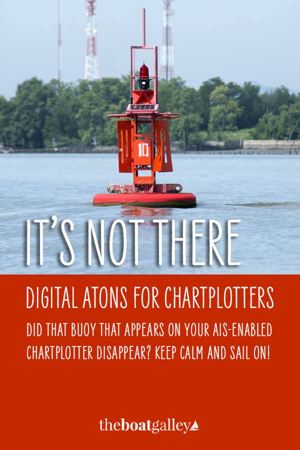
You enter between the breakwaters just after sunset, and, according to your electronic chart, you should see the channel buoys to port and starboard. Instead you see nothing at all. The buoys and beacons are gone!
What now, skipper?
What Does AIS Do?
The Automatic Identification System (AIS) enables vessels to see and identify other nearby vessel traffic. In the same way that aircraft broadcast information about themselves to air traffic controllers, a sailboat with a dedicated VHF AIS transceivers can transmit and receive ship information, such as the ship size, draft, position, speed, direction, cargo, destination and more.
What Will Visual AIS Aids to Navigation Look Like?
Sailboats, powerboats, or ships equipped with an AIS-enabled display can see the positions of other vessels up to 20 nautical miles away, even if they are behind islands or other obstructions that may block radar. But you may not know that the US Coast Guard has installed similar AIS features on some aids to navigation in US waters and territories.
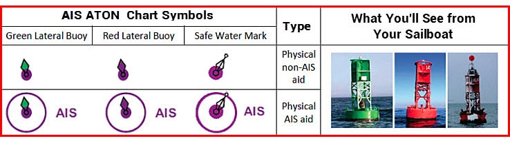
AIS transmitters can be affixed to a floating or fixed aid to navigation (AtoN), such as a buoy, beacon, or light. The AIS transmission provides the position and purpose of an aid, such as a port or starboard lateral buoy, even before it is close enough to be visible from the ship or to provide a radar return.
This can help mariners confirm their ship’s position or to prepare to make a turn that is based on passing a particular aid. AIS AtoNs are shown on NOAA charts with a magenta radio circle and an “AIS” label, as shown in the illustrations above.
What Will Virtual AIS Aids to Navigation Look Like?
A virtual AIS aid to navigation is a signal broadcast from an onshore AIS station to display at a particular location on AIS-enabled Radar, Electronic Chart Display and Information System (ECDIS), or Electronic Charting System (ECS) displays, but for which no physical aid to navigation at that position exists.
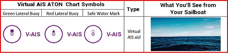
A few uses of virtual aid to navigation include environments where buoys are moved seasonally, such as in sea ice, or where a marker needs to be placed quickly, such as to mark a new isolated danger or wreck. NOAA charts depict virtual AIS aids to navigation with a magenta radio circle and a “V-AIS” label, as shown in the second illustration. Compare the abbreviations of the two panels. Notice the distinct “V-” placed before the “AIS” abbreviation in the virtual aids.
The purpose of the aid is indicated by the “top mark” above the central position circle. The lateral system uses a square for port side daybeacons or lights, and a triangle for starboard side daybeacons or lights. Note the small circular topmark on the far right symbol. This denotes a safe-water aid, which carries a single spherical topmark.
Click Here to download a complete list of the symbols and abbreviations used throughout the world to indicate physical and virtual AIS equipped aids-to-navigation on nautical or electronic charts.
Captain John is a Coast Guard veteran after over 20 years and has been a search and rescue coxswain, ship driver and certified master training specialist, with tens of thousands of sea miles traveled. He uses his years of experience on the water to offer e-books, articles, videos, and more on Captain John’s Skipper Tips for anyone who wants to be more competent on the water. He also offers a membership that gives full access to all his resources.
WANITA Meed says
How frequently is this happening? Is this just in the States so far? We are looking at heading down the Eastern seaboard from Nova Scotia in a couple of years. Are these virtual buoys common along that coast?
Carolyn Shearlock says
I wouldn’t say common yet, but they are there. I expect more and more of them particularly in areas used by ships.