Aqua Map is, quite simply, the best route-planning and navigation app that I have found. Whether you are using a tablet as your primary or backup navigation system, it can do everything you want.
I use it as on my iPad and find it to be equally as good as (and in some respects better than) our Garmin chartplotter. If you have a NMEA 2000 backbone connected to WiFi (or another WiFi capability), it can show data from an AIS receiver and your other instruments (we overlay AIS but do not have our other instruments connected to WiFi).
Background
Aqua Map is an Android/IOS app that you can use on a phone or, preferably, a tablet such as an iPad. The app itself is free but you have to buy the charts for the area(s) you’re cruising. Chart prices are in the very reasonable range — more on this below and a special 20% discount on popular chart packages. If you’re searching for the app, be sure to look for Aqua Map and not Aqua Maps.
Aqua Map Benefits
Aqua Map has clear, easy to see and use chart depictions. Where several chart options exist for a country, they opt to work with the one considered most accurate — for example, they use true Explorer Charts for the Bahamas.
Aqua Map basic features:
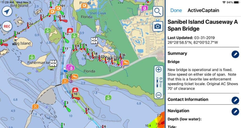
- Active Captain and Waterway Guide overlays showing marinas, anchorages and local knowledge – all for free
- Unlimited chart updates
- Activate only chart areas currently needed, reducing storage space required on device
- Simultaneously share charts across 5 devices (iOS and Android may be mixed)
- Anchor alarm included
- Easy-to-understand tide and currents while planning and navigating
- Easily create routes and tracks
- Routes and tracks can be shared with other devices (such as a chartplotter) and even other people
- Satellite image overlay possible when internet is available
- Extremely clear charts and symbols
- When navigating a route, easily jump to the next waypoint and see time to various waypoints further down the route, such as bridges and locks
Aqua Map Master, an add-on subscription, is well with the extra money (particularly cruising the US) as it adds:
- Route Explorer 2.0 — Find all hazards, alerts, locks, bridges, marinas, anchorages and fuel stations along your route/track and automatically see time and distance to each (iOS only)
- WiFi AIS and NMEA device connection (iOS and Android)
- US Army Corps of Engineers Surveys service – invaluable on the ICW and US rivers (iOS and Android)
- USCG Lights List – over 54K lights, buoys and beacon locations updated daily (iOS and Android),
- USCG Local Notices to Mariners (iOS and Android)

Aqua Map Chart Cost
Aqua Map’s charts cost less than many other apps and they tell you exactly where the charts come from. There is one price if you want access to the charts for one year (nice if you’re just transiting an area) and another for “forever” access (nice if you’re in an area more or less permanently).
Aqua Map has charts for much of the world, including the US, Canada, Bahamas, Caribbean, and Mexico. Much of Cuba is included as are most areas of Europe, Australia
The one-year charts are actually subscriptions so be sure to turn off the auto-renew before the year is up if you do not want that chart for the following year.
Active Captain, Waterway Guide and tide info (where available) do not cost extra, nor do you need an Active Captain or Waterway Guide account to view their info.
You can choose what areas of your purchased charts you want to download, so you do not have to take up storage space for charts you’ll never use (for example, I downloaded only charts for southern Florida, not the entire United States). Chart areas can be deleted once you pass out of an area and then re-downloaded once you return (helpful for conserving storage space if you’re doing the Great Loop, say). You do not need an internet connection except when you are downloading charts.
If chart tiles that you previously downloaded are updated, you can see this as a badge on the Download Charts icon. You can download updates to any charts you own for free — and yes, if you purchased “forever” charts, you can
My Experience
I downloaded the app plus the US and Bahamas charts to my iPad and then started exploring all the information that I had at my fingertips. Full disclosure: Aqua Map gave me the charts for free so that I could test out the app and review it. Don’t tell them, but having checked it out, I would happily pay for their charts! Having both Active Captain and Waterway Guide info and the true Explorer Charts is just that much better. The Master app and being able to access satellite maps in the app is icing on the cake.
Route Plotting
I next decided to plot a route that we’ll use to cross to the Bahamas in May. I have never before plotted a route on my iPad instead of using a mouse on my laptop and there was a bit of a learning curve. The Aqua Map very short tutorial, website help and some experimenting taught me everything I needed to know.
I would highly recommend plotting a route or two while you have internet access so that you can refer to their website help if you need it, although the offline help covered everything I needed.
Beware of Changing Units When Changing Chart Areas
The only potential problem that I noted is when you switch from a vector to raster chart area — such as when going from the US to the Bahamas. I had set my preference to show depth in feet and the chart did just that for the US. But the Bahamas were still in meters.There’s a simple reason for this — the Explorer charts are raster charts, which means they are essentially scans of paper charts. And Aqua Map does tell you of this limitation when you set your preference. Either you have to remember that the units change when you switch from one set of charts to the other or you can set your preference to meters and then the US charts will show in meters and at least the units will be consistent.
Features
Like most nav apps and chartplotters, you can set your average cruising speed and fuel consumption. There’s an anchor alarm right in the app — my minimal testing shows it to work well. Tapping two points with two fingers will tell the distance between them.
One feature that seems nice but I haven’t yet had a chance to use for real is what Aqua Map calls mapXpan — essentially the center of the chart is at whatever zoom level you select, and the edges go to a lower scale so that you can see 64 times the area. I think this will be helpful when trying to orient where an anchorage is in relation to other places or check out the route ahead to see where you are in relation to things like bridges. So many times with other programs you have to zoom in and out and I, at least, lose track of where I am.
Additionally, you can not only name your route (not sure what the character limit is, but it’s considerably longer than the 10 characters that Garmin gives me) but you can add a route description. This last is very useful if you’re creating several variations on a route.
Navigating with Aqua Map
Aqua Map is designed so that you can use it at the helm while navigating a route and is very straightforward. Tapping on the route info button will tell you time between each waypoint and from your current position to all the waypoints ahead. My chartplotter only tells me the time to the next waypoint and the final destination. So many times I want to know about an intermediate point, such as a bridge that only opens at certain times. Aqua Map definitely understands what type of information is most useful at the helm!

As with most chartplotters and nav apps, you can navigate a route either in the direction you entered the waypoints or in the reverse order.
Update: 18 Months of Using Aqua Map
We used Aqua Map as our primary navigation system our entire 3-month cruise to the Bahamas in the summer of 2019 and never had a lick of trouble with it. Our chartplotter began failing on that trip, so I was especially glad to have it.
It’s simply an intuitive nav program to use, and they keep adding features that are truly useful for mariners, such as the Route Explorer and Army Corps of Engineers depth information.
I highly recommend Aqua Map and even negotiated a 20% discount on popular chart packages for readers. Whether you are using a tablet as your primary navigation or as a backup, this is a wonderful and cost-effective app.
Transferring Route to Garmin Chartplotter
I’m a belt and suspenders type of girl. Even though I can navigate using the iPad, I want to also be able to transfer the route to our chartplotter and use it there so that I have a totally redundant backup in case either one fails.
It’s easy to transfer a route if your Garmin chartplotter is WiFi-enabled. Save it to Active Captain on the iPad and then sync the chartplotter with your Active Captain account.
It used to be possible to import to a non-wifi Garmin chartplotter using Garmin Homeport, but Garmin has stopped making that app available.
Aqua Map on Multiple Devices
You can put Aqua Map on up to five devices — Apple, Android or a mix. Here’s how to do it as sent to me in an email from the company:
The procedure to share any Aqua Map product with up to 5 devices (Apple and Android) is through the GEC Account.
- Register your GEC Account.
- Login from the Aqua Map Marine (free) to your GEC Account (this operation will register all the Aqua Map apps you bought, into your GEC Account)
- Download Aqua Map Marine (free) to the next device.
- Login from your other device to the same GEC Account…this will assign to your new device all the previously registered apps
Be careful, over 5 devices the user will be blocked and will be required to contact AquaMap.
Bottom Line
Aqua Map is the best route-planning tool I’ve used, with the Active Captain, Waterway Guide and US Army Corps of Engineers overlays. Being able to import tracks from other people (such as Bob423’s ICW tracks) is a very useful feature, as is the Route Explorer. The charts are top-notch and the cost very affordable when compared to other companies, especially when you consider that they can be shared across 5 devices.
I don’t think you’ll be a bit sorry with this purchase!


Carolyn Shearlock has lived aboard full-time for 17 years, splitting her time between a Tayana 37 monohull and a Gemini 105 catamaran. She’s cruised over 14,000 miles, from Pacific Mexico and Central America to Florida and the Bahamas, gaining firsthand experience with the joys and challenges of life on the water.
Through The Boat Galley, Carolyn has helped thousands of people explore, prepare for, and enjoy life afloat. She shares her expertise as an instructor at Cruisers University, in leading boating publications, and through her bestselling book, The Boat Galley Cookbook. She is passionate about helping others embark on their liveaboard journey—making life on the water simpler, safer, and more enjoyable.
Brian Ross says
Great information. I have used MX Mariner for years which comes with free NOAA charts, and pay charts for New Zealand, Brazil and the UK. Never an issue since our cruising was primarily on the great lakes and the US east coast. We have a raymarine chart plotter using Navionics charts for the US and explorer charts for the Bahamas, but I like the availability of the charts on tablets and phones. MX Mariner has a built in AC layer and we used it extensively when looking for marinas and anchorages, so I can truly appreciate having AC available on your charts. I may have to switch apps now that I have downloaded Aqua Map. Thanks for all you do!
Judie Miller says
Very helpful writeup, Carolyn. Thank you!
lexow grant says
Question: what iPad do you have? I wonder how aquamap works on older iPads?
Carolyn Shearlock says
I have a 2018. Maybe someone else with an older one will chime in.
Rex says
I have Aqua Map on my very old iPad. It is I think the second generation, probably 10 years old. Aqua Map works, but the charts redraw verrrrry slowly. It would drive me crazy trying to plan a route. Love the software so will probably buy a new iPad.
Bob says
Have been using garmin blue charts on my iPad in bahamas for 5 years- downloaded the agua maps app got the Bahamas explorer charts they look just like the chart books not like the charts that aqua maps have for Florida. I really like the detail on the garmin explorer charts and the aqua maps charts everywhere else than bahamas am I doing something wrong?
Rose says
Once again a great article…. As I am not super Techy, and have quickly scanned your article for a link, is there a way I can download this and support you?
Carolyn Shearlock says
Hi Rose! I don’t make anything on downloads, so just look for it in either the App Store or Google Play and download from there. Thanks for thinking of me though!
Eric Phinney says
Just returned from Bahamas where I have used Aqua Map for the whole time. Ran it on an old iPad 2 and a much newer iPad 3. Both worked well. I’m also a beta tester and am very impressed with the upgrades and changes I’ve suggested. Love the addition of AIS
Lawrence Toole says
Today 5/19/20 tried to download aqua map on my iPad 2. Would not download, said I have to have iOS 10, which iPad 2 can’t install.
Rodney L Foushee says
You can force ios 10 on iPad 2 by enrolling to Apple’s public beta program. And update ipad2 to ios 10 manually. and enjoy new iPhone update features First, you need to open your Safari web browser and go to Apple public beta website. You need to signup for the apple’s beta program to update ipad2 to ios 10 manually. Tap to the sign-up button.
lexow grant says
Thanks for your info. Getting explorer was a major coup for Aquamap. Can you tell me the operating system version number of your old and new iPads ? I’m assuming you’ve upgraded each as far as it can go.
Carolyn Shearlock says
I’m on 12.1.4, just updated. The iPad itself is a 2018 model.
Ted Broom says
Hi Carolyn,
Great and timely article, We hope to finally make the jump across this fall. Have you tried the Aqua Maps on Android systems? We have no IOS products, everything is android and windows… We are contemplating a new navigation system as our old Garmin 3210 is dying and there is no support for it, but will probably get another Garmin.
Ted
Carolyn Shearlock says
I haven’t tried it on Android (our Android tablet died a while back and we replaced with iPad) but I’ve heard from a couple of Android users that it works well.
John Kinney says
Thanks Carolyn, this is great and timely info, because I start south in March, and plan to be in the Abacos in early May. I was very disappointed about Garmin’s decision to drop Explorer, so I’ll check out Aquamaps. I looked at C-MAP’s Embark software because they still use Explorer as the basis of their data, but it has some pretty basic flaw’s, like no ability to do a quick measurement between two points on the chart. I emailed them, and they say improvements are coming, but in the meantime, I think I’ll get Aquamaps.
Terry says
Thanks for the article, Carolyn. I downloaded the app and will be playing with it to see how it works. I was wondering if your ipad is wi-fi only connectivity. I read a blog written by someone else that stated you need an ipad with 3G connectivity for the GPS. Thought I would check with you since you are the expert.
~Terry
Carolyn Shearlock says
Yes, it needs to have cell connectivity to use the iPad’s GPS. I get the GPS through an onboard wifi network from our boat’s instruments.
Molly on s/v Sabai says
I feel so inadequate! None of our chart plotters are young enough to even have WiFi. I assume we will not be able to interface any of this stuff. I already spoke to Garmin about using ActiveCaptain and they laughed. Not just snickers but outright guffaws. Our iPad is new so at least I can try the Aqua Mapp app and use it when we have internet. I’ll go back to my cave now . . .
Carolyn Shearlock says
Now you’ve got ME feeling inadequate, not only does my chartplotter not have wifi, I only have one!!
Judie Miller says
Molly,
I use AquaMap on my iPad without internet all the time. Once you download the maps (internet required for that step) and set up your settings, you should be able to see your vessel wherever you are, plan routes, and interface with Active Captain.
Carolyn Shearlock says
As long as your iPad is GPS enabled (either natively as it’s a cellular one or through an external GPS such as Bad Elf or wifi from your instruments that includes GPS), yes, you’ll see your position.
Judie Miller says
Yes, GPS enabled. Thank you for the clarification, Carolyn! 🙂
Stepheh Adkins says
Can not get wifi to work
Carolyn Shearlock says
Contact AquaMap tech support for help — they’re great. It works perfectly for me, so I’m sure they’ll be able to sort it out for you.
Morgan Youngblood says
We are newbies, but loving Aqua Map on the east coast. Their route explorer feature is helpful and also the connection to AIS is a bonus. We use a large iPad with the route zoomed in and a smaller iPad mini with it zoomed out to keep tabs on everything in the ICW. Seems like great software so far!
Chantal says
Friends told us about Aqua Map and we used it all throughout the Bahamas. The charts are better then Navionics especially the depth. It saved us many times especially in the Exumas. I haven’t figured out how to plot on it though. Will be looking into this for our next trip. Thank you
Bob says
Have been using garmin blue charts on my iPad in bahamas for 5 years- downloaded the agua maps app got the Bahamas explorer charts they look just like the chart books not like the charts that aqua maps have for Florida. I really like the detail on the garmin explorer charts and the aqua maps charts everywhere else than bahamas am I doing something wrong?
Carolyn Shearlock says
Nope, you’re not doing anything wrong!
That’s the difference between raster and vector charts. The ones you see for the US are vector; the Explorer charts are raster. At least my old Garmin Bahamas charts looked quite similar to the AquaMaps ones (it was on my chartplotter, not an iPad) as the underlying charts were the Explorer raster charts in both cases.
I’d love it if Explorer charts would move to vector charts, but until they do I’ll put up with them not looking as good but being much more accurate than any of the others!
Bob says
On aqua maps how do I get the charts I purchased to multiple devices I paid for a year of bahamas and got it on my iPad but when indent to download them to the aqua maps app on my phone it took me to the pay 34.99 site?says you can get them on 5 devices? Plus having trouble getting detail on several blocks some are fine but some wont zoom at all to get detail?
Carolyn Shearlock says
You have to create an AquaMap account on your iPad (from within the app, under settings — this should have happened when you bought the maps) and then put the app on your phone and login on it using the same username and password that you used on the iPad. If you have further problems, contact AquaMap’s customer service — they are really good and can help you far better than I can.
On the blocks that you are having problems with, have you downloaded the charts for those? If not, they won’t zoom with any detail. Again, the AquaMaps customer service is FAR better able to help you with these problems than I am — you generally get a reply from one of the company’s founders who know the product inside-out!
Bill Blevins says
This was stated in the comments in a round about way and so I thought I’d post more clearly. There is no real time GPS navigation with the brand new 2020 iPad Pro wifi only model unless you connect to another device with GPS. AquaMap only shows your boat moving along the map if you are connected to another device that is tracking you. Unfortunately Apple didn’t make it very clear and I sprung for the top of the line non-cellular iPad and using Aquamap is sort of a pain for navigation. The app is awesome for route planning. If you have another GPS that you can connect to WiFi then Aquamap is great. I blame Apple.
Carolyn Shearlock says
None of the non-cellular iPads have GPS, unfortunately. You can get an external GPS or you can piggyback off your phone’s GPS with a $10 app. Learn how to do that in GPS to WiFi iPad for Aqua Map.
Bill Blevins says
This link was helpful. About to get it all set up now. Thanks!
David Breeden says
We are ready to buy Aquamaps but need help on getting enough storage and processor speed to do the job successfully. What suggestions do you have for an Android tablet. The FAQ on Aquamaps website only say 6.0 or later but nothing about storage GBs or processor speed.
Thank you for your help.
Carolyn Shearlock says
I’m not at all an expert on Android tablets. In years past, we had three different Android tablets and had problems with all of them. This was long before Aqua Map and had nothing to do with it, and the problems we had with frequent lockups and poor battery life could be solved now. That said, about 2-1/2 years ago we switched over to iPads and have been so much happier. I had resisted an iPad for so long due to not wanting to have to learn an Apple system (I have a Windows laptop and my phone is Android) and because it was more expensive. I shouldn’t have worried about either. So my suggestion would be to think hard about getting an iPad . . . and if you do, get the cellular model (even if you don’t intend to put a SIM card in it — we don’t) because it has the built-in GPS.
john dyer says
Hey Carolyn,
Amazing article! I have been loving aqaumaps and especially importing the latest Bob423 tracks and army Corp surveys! Do you know how to import those Bob423 long tracks into homeport and then to my 7212 garmin non WiFi chartplotter? I get an error in Homeport when I try to import them.
Thanks!
John
Carolyn Shearlock says
You have to do the shorter tracks to import into Homeport, unfortunately.
Bruce Marshall says
After reading your article on the Aqua Map app I’ve just downloaded it and I’m wondering if you still provide a special price for The Boat Galley subscribers and guests. I’d like to know your price for the North America( forever) + Bahamas (forever) + Master (2yr) package if it’s still available. Would I order it through Aqua Map or through the Boat Galley website? Thanks for your help. Stay safe and all the best…..
Carolyn Shearlock says
Yes, you can get 20% off using this link: http://www.globalaquamaps.com/BG2020.html That’s a special page on the Aqua Map website and you order it there.
John Bryant says
I was very impressed with your info about Aqua Maps. I tried the free version and was very happy. I followed the link in this page to sign up and somehow I ended up with terra maps. I guess I get to see hoe their customer support works.
Carolyn Shearlock says
AquaMap and Terra Map are the same company, so no problem!
John Bryant says
I am happy to say I was contacted by support with very good instructions and telling me everything was setup. When I logged in everything was perfect. Very happy with their quick response and with the Aqua Map product.