
Cruising the ICW can be a wonderfully rewarding trip, but if you’re not prepared, it can be challenging. The Atlantic Intracoastal Waterway runs 1,088 statute miles from Norfolk, Virginia to Miami, stretching through rivers, sounds, marshes, and canals along the Eastern Seaboard. Thousands of boats make the run every year, north or south, spring or fall, while others simply live on or near the ICW and are just doing day trips.
This is the guide I wish we’d had before doing it the first time.
What Is the ICW?
The ICW (affectionately known as “the ditch”) is a protected inside route along the East Coast. It’s a connected series of rivers, bays, sounds, and man-made canals maintained by the Army Corps of Engineers.
The appeal is real. You travel through protected water with the coast beside you: no Gulf Stream to contend with, no cargo ships, no offshore swells. You stop when you want, whether in marinas or anchored in beautiful places, and you get to move at your own pace.
The drawbacks are real, too. You’ll motor more than you sail. Depth is another concern. While the official controlling depth is 12 feet, the channels can be shallower, especially after storms shift the sand, requiring you to play the tides. Bridges interrupt your progress on schedules you don’t always control. And some stretches, Georgia especially, will test your nerves in ways you didn’t expect.
None of that is a reason not to go. It’s a reason to be prepared.
What to Expect, State by State
The ICW mile markers run from 0 in Norfolk to 1,088 near Miami, so we’ll describe the route north to south, but it runs just as beautifully in either direction.
Virginia
Traveling from north to south is a gentle start. Well-maintained channels, modest tidal range, predictable conditions. Right out of Norfolk, you’ll face a choice between two routes, which we’ll cover later. Either way, Virginia eases you in.
North Carolina
North Carolina is where the ICW starts showing its personality. Two large open bodies of water, Albemarle Sound and Pamlico Sound, sit in the middle of the NC run. Both can kick up serious chop when the wind gets up. Cross them early in the day before the afternoon breeze builds, or wait for a genuinely calm window. Don’t push across either one in building conditions.
Shoaling is also a real issue throughout the Carolinas. What was charted at 8 feet last season may be 5 feet today, especially after storms. Your depth sounder is your best friend here.
South Carolina and Georgia
You’ll find the most beautiful and challenging stretches in South Carolina and Georgia.
Stunning marshes, Spanish moss, wildlife everywhere. And tidal ranges that will redefine your sense of the word. Georgia routinely sees 8 to 9 foot swings. The water that was comfortably under your keel at high tide may not be there six hours later.
TBG team member John Herlig describes exactly what that felt like on his first southbound run in Joy, Terror, and the ICW, including a grounding that became one of his best stories.
Near Savannah, the ICW crosses the busy Savannah River. Freighters move through fast and don’t maneuver easily. Look before you cross and hail commercial traffic on VHF 16 to announce your intentions before you commit. Similar ship traffic crossings exist near Charleston, Jacksonville, Port Everglades near Fort Lauderdale, and Government Cut in Miami. Give commercial vessels wide berth at all of them.
Florida
Florida is where the ICW settles down. Tidal ranges shrink dramatically as you head south, from about 5 feet near Fernandina Beach to under 3 feet near Fort Lauderdale. Channels are deeper and better maintained, services are more plentiful, but you’ll also find more boat traffic and more bridges.
One note for the southern end: the Julia Tuttle Bridge in Miami has a fixed clearance of just 56 feet, lower than the standard elsewhere on the route. If your mast and any antennas exceed 56 feet, you’ll need to exit the ICW at Port Everglades and re-enter after Government Cut.
Before You Go
Get towing insurance before you leave your home waters. SeaTow and TowBoatUS both offer annual memberships. A tow after a grounding or mechanical failure can easily run over one thousand dollars without coverage, and you usually have to wait at least 24 hours from subscribing to be covered. Set up your insurance before you leave.
Pack spares. Marine services exist along the ICW, but needing a tow or waiting at anchor for something that could have been handled in an hour is no fun. An alternator belt is the classic example: cheap, light, easy to install yourself, and impossible to run the engine without, as it usually drives the engine cooling pump as well. Bring the usual engine suspects, your electrical basics, and anything that’s failed you before.
If you’re not used to cold-weather boating, the northern sections can surprise you. Virginia and the Carolinas in fall can see overnight temperatures well into the 30s. Dealing with Cold Weather When Boating has practical tips for keeping the crew comfortable and the systems running.
Spend some time with your ground tackle before you go. The ICW has some of the best free anchorages you’ll find anywhere, and knowing your anchor setup cold means you can enjoy them rather than worrying through the night. How to Anchor a Cruising Boat is worth a read if it’s been a while.
If you’re a sailor wondering how much you can actually sail along the way, the answer is more than most people expect. Pamela Douglas from our team covers the whole question in Sailing the ICW.
Three Ways to Cruise the ICW
Boaters tend to approach the ICW in one of three ways:
- A destination of its own, with charming towns and a variety of scenery to explore
- A delivery trip, where they are just trying to get to their destination and make as many miles per day as possible
- A weather haven for days when travel offshore is inadvisable
Plus, of course, there are thousands of local boaters who access just small sections of the ICW.
The Daily Reality: Pace Yourself
Doing the ICW as a delivery trip is genuinely tiring.
Every day involves an early start, hours of focused attention at the helm, constant depth sounder watching, bridge timing, boats to pass and be passed by. And then, as soon as the anchor goes down, the evening planning session begins: what bridges tomorrow, what tide window for the shallow spots, where to fuel, where to anchor, what’s the weather doing. You eat dinner, go to sleep, get up, and do it again.
If you push hard, long days and a miles-first mindset, it grinds you down fast, especially on your first trip when you are still learning how it all works.
The people who enjoy the ICW most are almost always the ones who treated it as a destination in its own right, went slower than they expected, took lay days in interesting towns, and stopped treating the waterway like a problem to be solved.
How Far per Day?
A realistic day on the ICW covers 30 to 50 statute miles, depending on your boat speed, number of opening bridges and their timing, and current.
The ICW crosses inlets up and down the coast, and at every one, the current direction and strength can change completely. You can have a fair current pushing you along for an hour, round a bend, and suddenly be fighting a foul current that cuts your speed in half. It changes all day long, and is a combination of your location relative to inlets, the tides, and any river current.
We had days where we had mostly favorable current (yay!) and others where we fought it the entire time. Most nav apps try to forecast the current, but it’s almost impossible to check it for every mile at the exact time you’ll be there. Always allow extra time and be happy when you get more favorable current than expected.
Check sunrise and sunset times before you leave, and keep checking them as you go. A fall southbound trip leaving Norfolk in mid-October starts with about 11 hours of daylight. By November in the Carolinas, you’re down to 10 hours or less. Heading north in spring, you gain light as you go. The difference between 10 and 13 usable hours significantly affects what you can reasonably plan in a day.
With current and bridges playing such a big role in the daily trip, most people prefer to leave shortly after first light and plan their day to end three hours or more before sundown, giving themselves a time buffer if things go slower than expected. Entering an unfamiliar marina or anchoring after dark simply isn’t fun.
If things look like your planned stop may result in being on the ICW after dark, find a closer alternative. While a few intrepid souls try to run the ICW after dark, or even overnight, we don’t recommend it. At all. It is extremely difficult to constantly be watching for channel markers, unlit obstructions (including other boats), and shoaling.
Statute Miles
The ICW uses statute miles for all its distances and mile markers, not nautical miles. Mile Marker 0 is in Norfolk; Mile Marker 1,088 is near Miami. Before you leave, switch your chartplotter or nav app to statute miles. If your device is set to nautical miles, the distances won’t match what the waterway uses, which creates confusion right from the start.
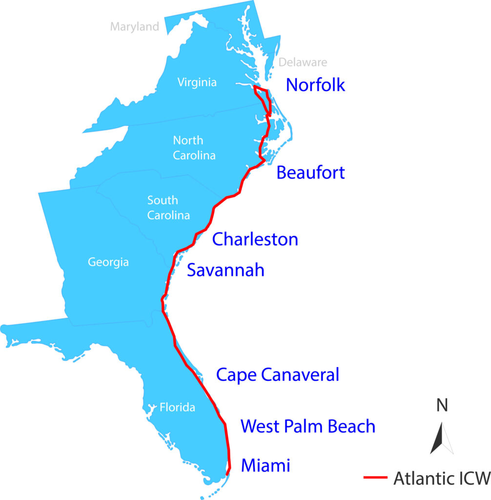
Reading the ICW Channel Markers
The ICW uses the standard US daymark and buoyage system of reds and greens, but with a few complications. You can’t simply remember “red right returning” and be set.
When you’re paralleling the ocean for hundreds of miles, what does “returning” even mean? The direction shifts constantly as the waterway winds through rivers, sounds, and inlets.
In general, reds are on the inland side of the ICW and greens on the ocean side, but that doesn’t help you when you’re going up a bay or river and both sides are “inland.”
To make it more complicated, the ICW frequently crosses or joins other established channels (inlets, rivers, harbors) that have their own red and green markers set for their own traffic direction, and the ICW may use those markers instead of separate ones. Consequently, when the ICW passes through, marker colors may suddenly reverse. Eek!
The solution to all of this: follow the small yellow markers. The ICW overlays its own system on top of everything else. Every ICW marker carries a small yellow triangle or yellow square.
- Heading south, keep yellow triangles to starboard and yellow squares to port
- Heading north, keep yellow squares to starboard and yellow triangles to port
The underlying daymark or buoy color simply does not matter. And if a mark does not have a yellow triangle or square, it’s not an ICW mark.
In practice, your chartplotter or nav app will show the channel and your position in it, which makes tracking the markers dramatically easier than it used to be. Still, know the yellow-triangle rule by heart. There will be moments when the screen is busy, and you need to eyeball the next mark quickly.
Know Your Draft and Air Draft
Knowing your draft (the depth of the deepest part of your boat) is one thing; knowing how your electronics display it is another. Depthsounders, on their own, read the distance between the transducer and the bottom of the water. Virtually all have the option to set an offset so that the reading at the helm is either the depth under the keel or the depth from the waterline to the bottom.
Before cruising the ICW, know exactly which yours is currently set to read and make sure it’s calibrated correctly. Checking Your Instruments walks through how to do that.
Your air draft is the height of the tallest thing on your boat above the waterline, usually your VHF antenna. Know this number before beginning your ICW trip and post it near the helm for quick reference.
Playing the Tides
There are certain stretches of the ICW that are known for shoals, and your boat may also be close to the nominal clearance of a particular bridge. If your draft or air draft is close on either one, you can play the tides to give yourself a little extra room.
Playing the tides means going through the shallow spots near high tide, and under the close bridges near low tide. Just be careful when you have a deep draft boat and are also close on bridge height. You may find spots where you simultaneously want both low and high tide! Be prepared to anchor up for an hour (or more) waiting for the exact conditions you need.
Ideally, with a deeper draft boat, try to go through shallow spots on “high tide rising”: above mid-tide but when the tide is still coming up. That way, if you do go aground, you should be able to back off in a half hour or so as the tide continues to rise.
If You Go Aground
Should you go aground, the immediate priority is to not go further aground. Assuming you’re motoring, put the boat in reverse and try to back off rather than drive her hard aground. If that works, check the chart to see where you should be.
Backing off doesn’t work? Then check the tide. If you’re not at high tide, the best thing to do is wait and see if the tide floats you free. If the wind is driving you further aground, put out an anchor astern to prevent that.
Shut down the engine to avoid problems with mud or grass being sucked into your engine cooling water, or having no water circulate if the boat heels.
If you have a monohull and the tide is falling, the boat will heel more and more as the water goes down. Make sure loose items are secured and take care not to fall and injure yourself.
If you are well and truly stuck, with no hope of help from the tide, it’s time to call on your towing insurance.
Navigating Bridges on the ICW
There are about 140 bridges between Norfolk and Miami. A little over a third of them are fixed highway bridges with a standard clearance of 65 feet or higher at mean high water. Cruiser lore says that several purported 65-foot bridges are actually a little shorter. Our Atlantic ICW Quick Reference Cruising Guide flags the ones believed to be closer to 64 feet.
Quick Tips for ICW Bridges
The bridge to really watch out for is the Julia Tuttle Bridge in Miami: it’s a fixed bridge with just 56 feet of clearance. If your air draft is higher, you’ll have to go into the Atlantic Ocean at Port Everglades and come back into the ICW at Government Cut in Miami.
The rest of those bridges are opening bridges. Depending on your air draft, you may or may not need all of them to open. When looking at charts or cruising guides, pay attention to how the bridge height is measured.
- It’s standard for the height to be measured at mean high water.
- Many states list the height as that of “low steel” or the lowest fixed spot of the bridge. There is usually more height in the center of the span; cruising guides such as ours will explicitly say things like “plus 3 feet at center.”
- There is often a light hanging down in the center of the span, and it is usually not considered in the measurements. If you are close on height, go slightly off-center so that your mast does not catch on the light.
- It’s always possible that bridge maintenance causes there to be less clearance than stated. More than once we’ve encountered hanging scaffolding that resulted in 5 to 10 feet less clearance. Not only that, but if we had hit the scaffolding, we almost certainly would have injured or even killed the workers on it. And there was no warning other than what we saw with our own eyes.
Remember to Check the Tide Boards
Fixed bridges and most opening bridges both have tide boards mounted to their fender systems, down at water level. The board is a graduated ruler. You read the clearance by looking at where the current waterline falls on the board, like the photo at right shows.
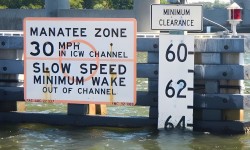
Charts give the published clearance at mean high water, but the actual clearance changes with the tide, whether wind is pushing water toward or away from the bridge, and rainfall nearby or upstream.
At low tide, you may have several feet more room than the chart shows. At high tide with wind-driven water or more than normal water from upstream, you may have less. Always check the tide board on any bridge where clearance is a concern.
On an opening bridge, the tide board tells you something even more useful: whether you actually need the bridge to open at all.
How to Request an Opening
If you’ve decided that you need a bridge opening, you must contact the bridge tender by VHF and request an opening. Many older cruising guides said these bridges opened “on demand.” We prefer to use the term “on request.” The bridge tender has the open button and all the authority: ask nicely.
Before You Call the Bridge Tender
Before you make the call, know three things: the bridge name, the VHF channel it monitors (they do not monitor channel 16, and what channel they do monitor varies by state), and whether it opens on request or on a schedule. If on a schedule, check when the next opening is. Note that many opening bridges have restricted schedules during morning and evening rush hours.
A good cruising guide (ours and some others) will have a mile-by-mile bridge list with all this information. Be sure to have one that is up-to-date, as bridge schedules do change, and it seems that at least one bridge a year is replaced and all the information about it changes.
Listen before you call on the VHF. Tune to the bridge channel as you approach, make sure you’re on low power, and hear how that particular tender runs things. Some are talkative, others very brusque. Find out what information they typically ask for, and be prepared to give it. Be friendly, be polite, and be prepared.
Making the Call
Your first call is just to make contact: the bridge name twice, then your vessel name. Nothing more yet.
“Royal Park Bridge, Royal Park Bridge — Distant Shores.”
The tender responds: “Distant Shores, Royal Park. Go ahead.”
Now give your direction of travel, a description of your boat, and your request.
“Royal Park, we’re a northbound trawler requesting your 2 PM opening, please.”
The tender confirms the opening. They may ask you to spell your vessel name, give your hailing port, or provide your USCG documentation number or state registration number. They may also tell you where to hold while you wait. Acknowledge and stand by on that channel.
When you’re through, say thank you.
“Royal Park — Distant Shores is clear. Thank you.”
Bridge tenders do talk among themselves. They will call ahead to the next bridge to warn the tender about rude or demanding boaters, who may then find themselves with extra-long waits.
Currents at Opening Bridges
When there’s current running, the convention is that boats going with the current go through first when the bridge opens. They can’t hold their position against the flow as easily as boats traveling against it. Always defer to what the bridge tender says, and take a moment to coordinate with any other boats waiting with you. Don’t assume other boaters know the etiquette. A quick call on the bridge channel takes ten seconds and prevents confusion.
Passing Through Locks
Both routes between Norfolk and Albemarle Sound involve locks: one on the Virginia Cut, two on the Dismal Swamp. Have your lines ready and fenders out well in advance of the lock.
Radio the lockmaster on the posted VHF channel to announce your approach, and if this is your first time through a lock, say so. Lockmasters are used to first-timers and will give you extra coaching through the process.
Inside the lock: don’t tie off. Hold your lines loosely so you can adjust as the water level rises or falls. Unless directed otherwise, keep your engine on but in neutral. Don’t let the boat bang against the walls. When the gates open, wait for the lockmaster’s signal before you leave. And again, be sure to thank them!
It’s more straightforward than it sounds, and there’s no penalty for asking questions.
Slow Passing: Avoid Being Waked
Boats on the ICW don’t all travel at the same speed. And they are all kicking up a wake, some smaller and some larger. The problem occurs when one boat passes another. If not done with care, the boat being passed may be “waked” and roll gunwale to gunwale because it cannot turn into the wake quickly enough. The boat and its contents can be damaged, and the people aboard can be injured, sometimes seriously.
ICW boaters have developed a system for boats closely passing one another.
- The overtaking boat calls the forward boat on VHF 16, switches to a working channel, and says they’ll do a slow pass and names which side they’ll go on.
- The forward boat acknowledges and slows to idle as the passing boat gets within 3 or 4 boat lengths astern of them.
- The overtaking boat also slows while making the pass, to decrease the size of their wake.
- Once past, the overtaking now-forward boat moves directly in front of the slower boat, and the slower boat speeds up to its normal speed and cuts inside the wake of the boat that just passed it. Being inside the wake protects them as the faster boat speeds back up.
- As soon as the slower boat is inside the faster boat’s wake, the faster boat can speed up (assuming it’s otherwise safe to do so).
Admittedly, not every overtaking boat will do the slow pass. But you should. If you are the faster boat, know that legally you’re responsible for any damage done by your wake. And if you get waked, try to get a photo of the other boat (preferably with their name visible) and report it to the Coast Guard.
Using Your VHF
Monitor VHF 16 all the time when you’re underway on the ICW, except when you are actually using another channel. It’s the law.
Use the Proper Power Level
There are lots and lots of boats on the ICW, and they are all using their VHF radios to call bridges, locks, marinas, and buddy boats, as well as to arrange slow passes, make emergency calls, and otherwise communicate with other boats. The airwaves can get extremely crowded!
Your VHF radio has a hi/low power button. Many boaters just use high power for everything, but that’s not necessary and is, frankly, inconsiderate.
VHF radios work on the principle that the highest power signal gets through and will override everything else. Using high power on a base station means that everyone within about 12 miles of your boat will hear your call and won’t be able to make a call themselves on that channel while you are talking.
For most calls on the ICW, low power is sufficient and will keep more distant airwaves clear for others. Use the chart below to determine whether you really need high power or not.
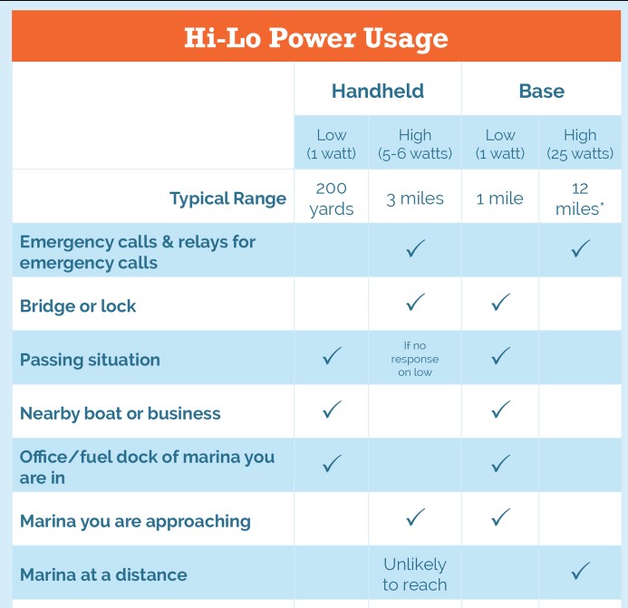
Keep Emergency Channel Free
If you call someone on 16, be sure to immediately change to a working channel to keep 16 free for emergencies and hailing. If you don’t, the Coast Guard is likely to break in and tell you to switch channels.
You’re probably starting to realize how many VHF calls you’re going to be making on your ICW trip with all the calls to bridges and locks. If you’re a little intimidated by the radio, our course VHF Radios: Everything You Need to Know covers channel selection, hailing procedures, and emergency calls in plain language. The Handy VHF Reference is a waterproof quick-reference card to keep right at the radio and includes the chart above.
Bob’s Tracks
You may have heard of “Bob’s Tracks” for the ICW and may even have heard that they’re a “must have.”
Bob’s Tracks are basically a route through the ICW, compiled by Robert Sherer (known throughout the ICW community as Bob423) to show the best path through the shallow spots. You can download the tracks and, depending on your chartplotter or nav app, may be able to display the track as an overlay on your chart.
Bob has a network of fellow cruisers and surveyors who report shoaling, dredging, and bottom changes as they happen, and he updates the tracks accordingly. The tracks show where they have found deep water rather than where the chart says it should be, and are generally more up-to-date than the charts.
Paired with the USACE surveys, they can give you a much more current picture of the bottom than official charts alone. Think of them as one more tool, alongside the depth sounder and the USACE surveys, all pointing you toward the same goal.
Now for the caveat: use Bob’s Tracks as a guide, not a guarantee. Bob himself is clear about this: the ICW is always changing, and even fresh tracks can’t account for every recent shift. Watch your depth sounder and stay in charge of your own boat.
One safety note worth taking seriously: some cruisers follow the track line rigidly and some even connect their autopilot to it. That can result in them not moving over for other traffic, even when there is plenty of depth. Don’t be that boat. Bob’s Tracks are a tool, not a line that you must rigidly follow.
Your Navigation App: AquaMap
For ICW navigation, AquaMap has become the app most experienced ICW cruisers rely on, and the reasons become clear quickly once you’re on the water.
The headline feature for ICW use is the US Army Corps of Engineers depth surveys: over 90,000 of them, overlaid directly on the chart and updated weekly. In an area where official NOAA charts can lag months behind the actual bottom, those surveys are genuinely valuable. In the Carolinas and Georgia especially, where channels shift constantly, they can make the difference between finding the deep water and finding the sandbar.
You can also get Bob’s Tracks automatically. Set AquaMap to sync them anytime your device has an internet connection, and the version on your device is always the latest one. As soon as Bob issues a revision, it appears on your chart.
AquaMap also displays your current mile marker right on the chart, making it easy to cross-reference with any guide that lists locations by mile marker (like ours). The Route Explorer feature shows every bridge, hazard, marina, anchorage, and fuel stop along your planned route with ETAs, so you can see what’s coming up before you get there.
AIS integration puts other vessels on your chart. The anchor alarm with AnchorLink monitors your position and alerts your phone if the boat drags, useful when you’re ashore in town. Navigation aids update daily through Local Notices to Mariners. And you can set the charts to update automatically, too.
Get 20% off AquaMap charts through TBG’s dealer link. Download the app on your device first (iOS or Android), then use the link for the charts.
Planning Your Stops
If you’re not planning a lay day, you’ll want to do a bit of planning each evening for the next day’s run.
Things to consider:
- Attractions: places you want to visit. The ICW passes through wonderful towns and natural areas. We share some of our favorites in the next section.
- Need for services: fuel, water, parts, pumpouts, laundry, groceries, propane, or anything else
- Bridges and when they open
- Anywhere you need to play the tides, and the best time to go through that area
- Known navigational challenges (shoals, swift current, large tide swings)
- Marinas, free docks, and anchorages, depending on your preferences
- Bail-out spots if needed
Free Docks
Free docks are one of the ICW’s underappreciated assets. Dozens of waterfront towns along the route offer free dockage, some overnight, some day-use only, right where you want to be for provisioning, laundry, and exploring. You can often handle everything in a few hours without paying for a slip. Our cruising guide lists all of them.
Marina Reservations
At popular stops during peak season, particularly Charleston and Beaufort, NC, slips fill weeks in advance. If you have a specific stop in mind, call ahead. Anchoring out gives you much more flexibility.
Provisioning
Finding food and supplies is easier than you might expect. Towns come along regularly enough that you don’t need to load for weeks at a time. Travel relatively light and replenish as you go.
Pre-Planning
The old way to plan an ICW day was to spend an hour or more each evening reading through multiple resources and hand-writing lists: which bridge opens at what time on what channel, fuel stop depths, anchorage protection direction, pumpout locations, free docks.
It worked, but we thought it was sort of silly for everyone to be spending hours creating the same lists. Why not create them once and share them?
That’s exactly what our Atlantic ICW Quick Reference Cruising Guide does. Unlike a traditional mile-by-mile narrative guide, it’s organized by topic first (bridges, anchorages, free docks, marinas, services) and within each topic by mile marker.
When you want to find the next fuel stop, you look at the fuel table and scan down. If you need laundry, a pumpout, or groceries, use those columns. When you want an anchorage with good north protection and dog-walking access, you look at the anchorage table. You find what you need in seconds rather than having to read pages of text.
Virginia Cut or Dismal Swamp?
Between Norfolk and Albemarle Sound, you have a choice of two routes.
The Virginia Cut (also called the Albemarle and Chesapeake Canal) is the more popular option: deeper, more straightforward, and one lock. It takes you right through Coinjock, a popular stop (see below).
The Dismal Swamp Canal is shallower (with a controlling depth of 6 feet; any draft over about 5 feet gets uncomfortable) and has two locks. It runs through a genuine old-growth swamp: narrow, quiet, and wild. Primordial, even. The overhanging trees are spectacular, but the canopy is tight. A 60-foot air draft is pushing the limit; taller masts have made it through, but carefully. Know your numbers before you commit.
The routes rejoin in the Albemarle Sound. If your boat can handle it, at least one trip through the Dismal Swamp is worthwhile.
Favorite Stops
The ICW passes through places you’ll be glad you didn’t rush past. Here are six worth planning around, running north to south.
Coinjock, North Carolina
Coinjock, NC at MM 50 is usually one of the first real overnight stops southbound from Norfolk on the Virginia Cut route. The marina restaurant has been an ICW institution for decades, famous for its 32-oz prime rib. Call ahead and reserve your cut when you book the slip, because they do run out.
Beaufort, North Carolina
Beaufort, NC at MM 204 (pronounced BOH-fort, not to be confused with Beaufort, SC, which sits 330 miles further south and is pronounced BYOO-fort) is a genuinely charming waterfront town with excellent dinghy dock access, a good maritime museum, easy provisioning, laundry within walking distance, and a lovely anchorage in Taylor Creek. Most people who stop there end up giving it a lay day.
Charleston, South Carolina
Charleston, SC at MM 470 is the one everyone tells you to give more time than you planned, and everyone is right. Historic waterfront, extraordinary food, walkable neighborhoods full of antebellum architecture. It’s the kind of city that turns a transit into a real destination. Give it two or three days if you can.
One of our favorite places was the Historic Charleston City Market, where Gullah artisans weave and sell sweetgrass baskets. It’s one of the oldest African American art forms in the country. We were there shortly after our wedding and spent some of our gift money on a basket we still have. That’s Charleston: you wander in for an afternoon and leave with something you’ll keep for decades.
Savannah, Georgia
Savannah, GA sits about 8 miles up the Savannah River from the ICW, a short diversion that’s consistently considered one of the best cities on the entire East Coast. Laid out in squares, each anchored by a small park, lined with historic homes and good restaurants and easy to explore on foot. One caution: the Savannah River sees active freighter traffic. Look before you cross and hail commercial vessels on VHF 16.
Cumberland, Georgia
Cumberland Island, GA around MM 714 is hard to put into a category. Anchor off and dinghy ashore to a largely wild, uninhabited barrier island: wild horses roaming through the ruins of a Carnegie mansion, ocean surf audible from the anchorage at night, skies dark enough to actually see stars. The National Park Service now requires advance reservations for shore access, so plan ahead. It’s one of those places cruisers talk about for years after.
Titusville, Florida
Titusville, FL at MM 883 is the Space Coast. Kennedy Space Center is a cheap Uber away, and if you can time your stop to a launch (the schedule is publicly available) you can watch a rocket lift off from your cockpit. Disney and Universal in Orlando are about 50 miles inland; car rentals are available right in Titusville if you want a day at the parks.
One more worth noting: West Palm Beach around MM 1015 is the traditional gathering point for cruisers staging for the Bahamas crossing. From mid-October through early March, The Boat Galley hosts Dutch-treat Friday afternoon cruiser happy hours. Sign up for the TBG newsletter for details.
Cell Coverage on the ICW
Cell coverage along most of the ICW is good and improving steadily. For the majority of the route, you’ll have reliable data and voice coverage, no matter what network you’re on.
The exceptions are the more remote stretches of North Carolina, particularly the Alligator River area and the Alligator-Pungo canal, which runs through a wildlife refuge with no towns nearby. Some isolated Georgia marsh sections can also be thin. These gaps tend to be brief.
The Best Part
No amount of preparation fully captures what the ICW is actually like.
Anchor in creek so quiet you can hear the birds settling into the marsh grass at dusk. Watch dolphins follow your bow wave through Georgia at sunset. You’ll pull into a town you’d never have found any other way and end up staying two days longer than you planned.
The ICW has a rhythm to it. Once you settle in, it gets easier every day. The channel markers start making sense, the bridge calls feel routine, and the community of boats moving through at the same time starts to feel like something real.
Go. You’re more ready than you think.
Ready to Cruise the ICW?
Yes, we’ve mentioned our Atlantic ICW Quick Reference Cruising Guide a few times. We can’t help it. After years of spending evenings making those lists by hand, we’re genuinely proud of what we built. Here’s where to get it:
- Spiral-bound or PDF from our store (no shipping address needed for PDF; get it immediately)
- Spiral-bound on Amazon
- Kindle on Amazon


Carolyn Shearlock has lived aboard full-time for 17 years, splitting her time between a Tayana 37 monohull and a Gemini 105 catamaran. She’s cruised over 14,000 miles, from Pacific Mexico and Central America to Florida and the Bahamas, gaining firsthand experience with the joys and challenges of life on the water.
Through The Boat Galley, Carolyn has helped thousands of people explore, prepare for, and enjoy life afloat. She shares her expertise as an instructor at Cruisers University, in leading boating publications, and through her bestselling book, The Boat Galley Cookbook. She is passionate about helping others embark on their liveaboard journey—making life on the water simpler, safer, and more enjoyable.
Leave a Reply